

Appleby History > In Focus > 10 - Medieval Open Fields
Chapter 10
Identifying Appleby's Medieval Open Fields - Part 2
by Richard Dunmore
In this second article about Appleby’s medieval Open Fields, I shall look at the three remaining Fields which lay mainly in Leicestershire, on the southern side of the parish. These relatively large Fields were quite different in character from the five smaller Derbyshire Fields which were developed and managed by Burton Abbey. The Abbot was their landholder at the time of Domesday (see Part 1).
The Field Towards Snarestone and The Field Nigh Norton may likewise represent the respective Leicestershire Domesday holdings of the Countess Godiva and Henry de Ferrers. Dingle Field which straddled the county boundary line and is not mentioned in the 15th Century Glebe Terrier, seems to be a later encroachment on the heathland towards No Mans Heath.
The Field towards Snarestone
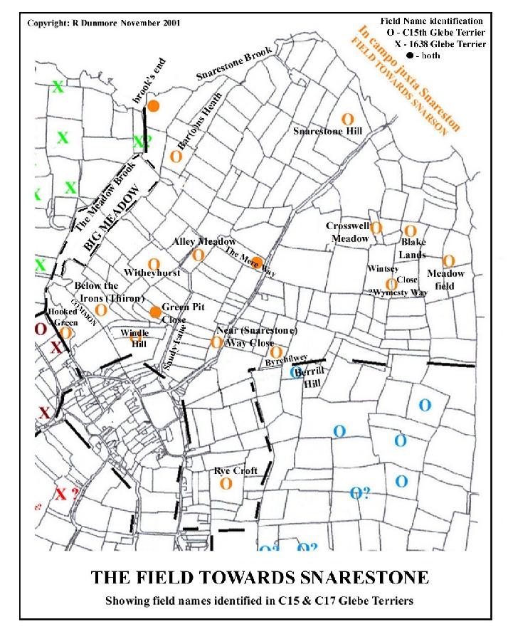
The Field towards Snarestone was a large Field, even in the 15th century. The rectory held 72 separate areas of land varying from 1 to 4 ‘lands’ (strips). It is difficult to estimate the total area of the rectory land holding because of the uncertainty of the size of a ‘land’, which was perhaps a half or one third of an acre (1). In the rectory’s possession there were in total 160 lands, 6 headlands, 17 butts (short lands); and, in more familiar measurement, 3 acres and 8 rods (roods or quarter acres).
 Click for larger view |
So the total area of land held by the rectory in this one Field alone was somewhere between 60 and 90 acres. Allowing for variations in spellings, the number of names of furlongs, ‘greens’ and ‘ways’ listed is 33. Seventeen of these survived as 19th century field names and the spread of names over the Open Field has allowed its bounds to be mapped quite closely.
Greens and Leys
Greens may be thought of as special areas of quality common pasture, ie grazing land, enclosed from ancient times and subject to the rules of the common. There were two greens named in this Field. Hooked Green was situated close to the village below Old End and by the Meadow Brook where its fertility would be assured. In 1638 the rector held ‘four leys lying at Hooked Green, the land which was Mr Brewerton’s west, the common east’.
Leys were a 17th century development in ‘convertible’ husbandry in which land use alternated between arable and pasture, each phase occupying a period of several years. This enabled the introduction of new crops such as roots and clover, and the support of more stock especially sheep (2). It would appear that at least part of the original ancient pasture of Hooked Green had been adapted in this way. By 1638 the rector held four leys on the Hooked Green which he would use for arable crops for a few years before reverting to pasture.
There was an area of common land to the east of these rectory leys which may have formed part of the original Green. There must have been access to this common from Old End and it would have stretched down to the meadow land which lay alongside the lower reaches of the Meadow Brook. The area around Hooked Green demonstrates that land was continually being adapted to meet the needs of the time.
Crassewell Grene (several spellings) lay about 1 mile from the village, a short distance SE of the buildings of the modern Lower Rectory Farm. By the 1690s when land was purchased for building the School, the ‘Field towards Snarestone’ had become known as ‘Crossald Field’ (1). In the Appleby parliamentary enclosure award (1772), there is reference to Crossal Close but the Field name had changed to Wind Mill Field (3). The name occurs again in 1832 in Crosswell Meadow, one of several irregular enclosures. Its very irregularity is suggestive of an ancient survival; the meadow may even have been all or part of the green. Piecemeal enclosure may have left Crosswell Green at the core of a dwindling ‘open’ area of the Field. The name Crosswell was then naturally adopted for the diminishing Field itself.
The 1832 map, which I have used as the background map on which to plot the Open Fields (4), is highly suggestive of field reorganisation in progress following the Parliamentary Enclosures. Larger rectangular fields were being developed around irregular-shaped survivors like Crosswell Meadow. Later Ordnance Survey maps show that the whole of this area, which was part of the rectory’s award in 1772, had succumbed to reorganisation. The old smaller irregular shaped enclosures, including Crosswell Meadow, were obliterated. In our own day, many of the ‘modern’ fields themselves have vanished (5).
Field Names
The correlation of names derived from Glebe Terriers with modern field names is given in Appendix 1 for the Field towards Snarestone and the location of each of these is plotted on the map (above). Several of the names are worthy of comment.
Rye Croft formed a south-western extension of the main bulk of the Field and lay to the south-east of Top Street. It was on part of this land that the School was built in the 1690s (1). The name refers to the cereal crop rye, used for fodder, and once grown there. In a similar way Windle Hill , to the east of the modern Black Horse Hill was where windle, a special grass used for plaiting, was grown. Below the Irons refers to the bends in a river or stream (6). Snarestone Hill can still be observed, despite (or perhaps because of) the removal of all hedgerows in its vicinity. Returning to Appleby from Snarestone, it is the low hill on the right immediately after entering the parish over the Mease (alias Snarestone brook).
‘Ways’: Roads and Tracks
With land holdings scattered about the Fields, access was important and was provided by roads, lesser ‘ways’ (tracks) and headlands alongside the arable strips. The main ways were named and many can be identified. In this Field, as well as the Snarestone Way itself, there was Berrill Hill Way which followed much of the present lane to Upper Rectory Farm (7). This formed the boundary with the Field nigh Norton which lay to the south-west. The Mere Way, at right angles to Snarestone Way, led directly to where Barns Heath farm now lies. Immediately opposite is the probable location of Wymesty Way (8). Nearer the village and taking a fairly direct route from the modern Jubilee Farm to Barns Heath lay Sandy Lane (9).
It is apparent that these ancient ‘ways’ survived the 18th century enclosures. Indeed, as established routes giving access deep into the old Fields, they seem to have been a determining factor in establishing the locations of the new farmsteads and other outlying buildings. These buildings were erected close to the ‘ways’ crossing the tract of land which was to form Barns Heath and Upper Rectory Farms.
Barns Heath
I have noted previously that the name Barns Heath must be a corruption of Barons Heath which occurs in the 15th century Glebe Terrier (10). It is likely that the name goes back to the Norman baron, Henry de Ferrers, one of the three Appleby landholders mentioned in the Domesday survey. The Saxon Countess Godiva had clearly been dispossessed of her estate at Appleby Magna by 1086. It seems that de Ferrers moved quickly to acquire her land, including the heath, to add to his Domesday holding at Appleby Parva. Certainly by 1240, Appleby Magna manor was held by William de Appleby from the Earl Ferrers for knight service, so it had become part of the Honour of Tutbury (see In Focus 7).
The Field nigh Norton
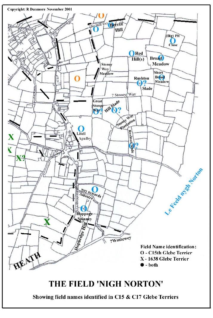
The Field nigh Norton was a second large Field on the Leicestershire side of the parish. This must have developed from the small Appleby Parva estate held by Henry de Ferrers at the time of the Domesday survey of 1086 (11). It stretched from Berill Hill Way (at the boundary with the Field towards Snarestone to the north-east) across the modern Atherstone Road and up the West Hill as far as Hophynch or -hinge, whose name still survives in Hop Hedge or Hoppage Spinney. This lies beyond the wey towards Aldestre (Austrey Lane). In the 15th century, the rector held eight lands under Litell Apulby, so the Field lay close to the hamlet. In all the rector’s land holdings, the Field nigh Norton was second only to the Field towards Snarestone, with 98 lands, 7 headlands, 35 butts, 1 ley, 4 acres and 7 rods.
 Click for larger view |
The total area is estimated as 45 to 70 acres, depending on the size of a ‘land’ (1).
Appendix 2 shows the correlation of furlong names with post-enclosure field names for the Field nigh Norton and their distribution can be seen here on the map of the Field.
Slades
One of the main features of this part of the parish was the number of slades. These were shallow valleys or green ditches through which water drained down towards the village from the hillside (12). In this Field, the 15th century Terrier names Oldhillslador Oldingslade, Rowlaoslade or Rowlowslade, Rytheslade and simply the slade. Modern field names for this area include Hill Slade, Rushton Slade, Rushton Slade Meadow, Great Rushton Slade and Rushy Slade. The precise correlation between these is difficult, except perhaps (Old) Hill Slade, but there is no doubt that they all lay within this part of the parish (13).
Ways
Mention has already been made of Berrill Hill Way on the north-eastern boundary (see above) and the wey towards Aldestre (Austrey Lane). The latter forked at the second corner of the lane, with Hophingwey leading straight up the hill to Hoppage, which probably originated as an enclosed part of the heath on the hill (14). In the centre of the Field, there are several features carrying the name Stoney Way, ie meadow and plantation; and Great Stoney Way (field). Stoney Way itself probably ran from a point on the (modern) Top Street near the School straight out across the Field, forming part of a route to Norton. Much of it survives as a footpath right of way.
Seventeenth Century Changes
The Field nigh Norton is absent from all of the Glebe Terriers of the 17th century ie 1606, 1638 and 1679, although the rectory held land in each of the other seven Fields in 1606 and 1638. This was reduced to six Fields in 1679, when the rectory also had no land in Bridge Hill Field. It is important to try to work out why this should have been.
Two significant events affected the parish resulting from the upheaval of the Reformation. First of all, with the dissolution of the monasteries, Burton Abbey was dissolved in 1539. The Derbyshire manor of Appleby Magna was sold and the land of the five Open Fields acquired new secular owners. By 1605 the land had been acquired by the Dixies of Market Bosworth as an endowment for Bosworth School (15). Meanwhile, the Leicestershire manor of Appleby Parva was purchased by 1599 by Charles Moore who, with his successors, was bent on building up a considerable landed estate (16).
It seems that the Moores, supported by the better-off farmers, overrode the wishes of the smaller landholders of the village in consolidating enclosures of land, particularly in this Field which lay nearest to their home farm at Appleby Parva. Enclosed blocks of land strips could be farmed more profitably than could scattered strips. Conversion of blocks of arable land to pasture, eg as leys (see above), enabled the lucrative rearing of sheep. The evidence of the Glebe Terriers is that the Moores achieved this conversion quite speedily. Land strip entitlements of the smaller land holders, including the Rector, must have been reallocated to the other Fields - without their consent. This explains why the Rector held no land in the Field nigh Norton from as early as 1606.
Alan Roberts has found confirmation of a ‘gentry-led enclosure movement’ in a suit in the Star chamber initiated by the Rector in 1636 (17), who was protesting at the wealthier landowners ‘making exchanges [of land strips] for enclosing...’ The defendants were accused of ‘turning arable to pasture, and of making enclosures from the common pastures and meadows without the consent of their neighbours’ (18). The Rector’s second largest holding was in this field (see above). It is not surprising that he led the protests against the enclosures and the ensuing land exchanges which disturbed his familiar areas of cultivation.
The Moores did not enclose all of the Open Field. They enclosed land adjacent to their manor buildings at Appleby Parva and the Field nigh Norton continued to exist under an amended name. This reflected the fact that its remnant of ‘open’ acres were more distant, near the parish boundary at Norton Hedge. The Appleby Enclosure Award of 1772 allocated to the Rector 101 acres of land in Norton Hedge Field, one of the boundaries of the area being the Lordship of Norton. Incidentally this acreage joined on to another block of land allocated to the Rector in the Windmill Field (otherwise the Field towards Snarestone, see above) and together these were to become the Rectory Farms.
The Dixies of Market Bosworth acquired much of Appleby Magna manor, with its smaller Open Fields, and similar enclosures may have been made by them or their tenants in the Bridge Hill Field. That Field’s absence from the 1679 Glebe listing may therefore be explained in a similar way.
Greens
No green was listed in this Field in the 15th century but, as in other Fields, it is likely that areas of quality grazing land were reserved for rearing stock. A lease of land dated 1262 refers to half an acre of land in Appleby Parva abutting on ‘West Well Grene’ (19). This green was clearly close to Appleby Parva and by the 17th century may well have been absorbed into the Moore’s estate.
The Dingle Field
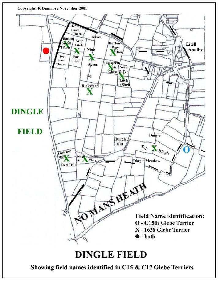
Dingle Field is first recorded in the 1606 Glebe Terrier. It lay across the county boundary line which approached the village from No Mans Heath and, of the furlong names, many are derived from local topographical features. The prime example is the eponymous Dingle, a wooded hollow which lies a short distance north of the modern Dingle Farm. A stream rising in this area flows down the dingle hollow, across the Tamworth Road and, passing west of Chilcote, joins the Mease nearby (20). Many names (Small Thorn, Nine Acres, Tamworth Pit, Red Hill, etc) derive from Old English but give little impression of antiquity. It may be concluded from this that most of Dingle Field is a relatively late development.
 Click for larger view |
With the expansion of the village population and its growing agricultural needs, it became necessary to take land into cultivation around the edges of the parish, especially from the heathland on the surrounding hills. The first areas of land won from the heath could at first have been attached to the Middle Clayfield towards Stretton, just as the enclosure of the heath at Hoppage had been attached to the Field nigh Norton.
By 1606, new furlongs had been cultivated to the west of the Burton Road over an area sufficiently large to be organised as a separate Field. After the dissolution of Burton Abbey, with its Derbyshire loyalties, the county boundary ceased to have any relevance to the village’s agriculture and the bounds of the new Field disregarded it. Appendix 3 shows the correlation of furlong names with post-enclosure field names and their distribution can be seen here on the Field map.
Greens
In the 1638 Terrier the rector held 1 land at Annescote green, the land to the east was held by Thomas Pecher; and that to the west had been held [ie until recently] by Thomas Learyes. The name of the green suggests that it lay near a cottage (Anne’s cote), perhaps one of the cottages of Appleby Parva, but we cannot say precisely where. The division of the green into lands again demonstrates that convertible husbandry was being practised (see above).
Ways
There are no specific references in the 1638 Terrier to roads or ways in this Field other than the Burton Road: 1 land sitinge over Burton way. The location of Burton way close as a modern field name shows that the stretch of road referred to here is that between Appleby Parva and the cross-roads with Tamworth road. There is no reference to Dingle Lane but that may be simply because no rectory lands lay near it. Along Dingle Lane there were modern fields called Great and Little Potway (1831), which must originally have been Portway, meaning a gateway (21). Dingle Lane must have been a main route out of the village, an earlier road from Appleby to Tamworth. The route through to No Mans Heath would certainly appear to be ancient (22).
Notes and References
1. Richard Dunmore, This Noble Foundation: a History of the Sir John Moore School, School Trustees, 1991, p 121. In setting up the School, Sir John Moore by ‘bargain and sale’ entrusted the newly appointed governors with ‘... seven lands or sellions of ground ... at a place and on a flat called Roycroft containing by estimation two acres and a half, or thereabout, ... also four lands or sellions lying on the said flat called Roycroft containing two acres... situate in a field, called Crossald Field ...’ At this time therefore the size of a ‘land’ was in the range one third to one half an acre, but this was not necessarily always so.
2. Christopher Taylor, Fields in the English Landscape, p 119-120 (leys).
3. Appleby Enclosure Act (1771) and Award (1772), Leicestershire Record Office 15D55/44. J Nichols (p 432) records that a Windmill was built by public subscription in 1802. This must have replaced the one implied by the Enclosure Award.
4. Map of the Parish of Great and Little Appleby in the Counties of Leicester and Derby, 1832 and Reference 1831, scale 8 in:1 mile (in the possession of Sir John Moore School Trustees).
5. The extent to which hedges have been removed around Barns Heath Farm and the Upper and Lower Rectory Farms is apparent from the latest O.S. Explorer maps, 232 (Nuneaton and Tamworth) and 245 (The National Forest).
6. Windle plaiting grass, as in windlestraw old stalk of kinds of grass for plaiting (Old English), OED; Iron variation of Hirn or Hyrne (Old English) nook of land; land in the bend of a river, J Field, English Field Names, David and Charles, 1972
7. Berrill Hill derives from the growing of another crop, barley (see In Focus 4)
8. Mere may have been a pond; Wymesty is equated with Wintsey, a surviving field name.
9. Sandy Lane, shown on my map, survived as a useable lane well into the 20th century and is still a right of way, marked as a bridleway on O.S. Explorer maps, 232 and 245. Sandy Furlong must have been nearby. The removal of all hedges and other recognisable features of the landscape means that effectively the lane has been sacrificed to the demands of modern agriculture.
10. In Focus 4 (Barns Heath a corruption of Barons Heath).
11. A small tract of land was occupied here at the time of Domesday by the sokemen, probable descendants of the Danish invader-settlers (see In Focus 4). It is notable that the surviving Danish name elements are concentrated not here, but in Meadowbrooke Field, where the Danes would have first established a foothold in the parish. The Field nigh Norton appears to be thoroughly anglicised, perhaps indicating that the larger part of its development took place in the medieval period.
12. Modern field drainage, channelling water through field boundary ditches, has largely removed the slades as features of the landscape. Small-scale undulations still occur in the fields and a survey of height contours at an appropriate scale could well reveal the old drainage lines. Aerial Photography may also show them up.
13. There are only two other slades mentioned in the Terriers, one in the 15th century in the Cleyfeld (later known as Fishmarlepit Field) and the other in Meadowbrooke Field in 1638. These must refer to tributary drains of the Meadow Brook, the first in the lower village and second even lower downstream, both draining the higher ground towards the Great Heath. There is also reference to a green ditch on Ryecroft, the section of the Field towards Snarestone which interlocked with the Field Nigh Norton and therefore quite close to the slades named here.
14. Hoppage, hophynch, hophingewey: derived from hop- OE small enclosed valley or enclosure on the heath; and -ing OE stream. Hoppage Spinney, on the hillside, has the source of the stream which flows through Appleby Parva. Culverted under the old Appleby Hall grounds, it emerges near the top of Church Street. Hophingewey, or Hoppage Way, is still used as a farm track by vehicles on West Hill Farm.
15. In Focus 8 (dissolution of the Abbey; purchase of Appleby Magna manor by the Dixies).
16. Nichols op.cit p 443, Charles Moore, Lord of Manor of Appleby Parva, 1599
17. Nichols op.cit. p 436, Thomas Mould, Rector 1610-42
18. Alan Roberts, Appleby’s Open Fields in the Early Modern Age, see this web-site. As the Rector and his successors continued to hold no land in the Field nigh Norton throughout the 17th century, presumably his action was unsuccessful.
19. See In Focus 6, Hastings MSS, ‘West Well Grene’
20. It is remarkable that so few streams flow out of the parish without joining Appleby’s Meadow Brook. These occur only at the extreme edges of the parish and several have been used to define parish boundaries. Before it joins the Mease, the stream from Dingle hollow defines part of the boundary between Chilcote and Clifton Campville. Another stream, flowing north-westwards to the Mease, just west of Manor House Farm, defines a stretch of the boundary between Appleby and Stretton. Waters flowing off the northern side of Birds Hill and, again, off the eastern side of the high ground around Upper Rectory farm also flow directly into the Mease. One of the latter water courses shapes the Appleby boundary with Norton before it joins the Mease near Snarestone.
21. Great and Little Potway, named in the 1831 Map Reference; united field marked on OS 1:25 000 Second Series at SK 305 088; port (OE) gate: the gateway gave entrance to or exit from the village
22. See my note on No Mans Heath, In Focus 2
APPENDIX 1 - THE FIELD TOWARDS SNARESTONE
Name Correlation between Open Field Lands and C19 Closes
|
C15 Glebe Terrier (after Nichols) |
1638 Glebe Terrier
|
Post Enclosure Field Name |
O.S. Grid Ref SK - |
|
IN CAMPO JUXTA SNARESTONE |
FIELD TOWARDS SNARSON |
|
|
|
IIII lands in Rycroft extending in le grene diche |
(absent)
|
Great/ Little Rye Croft /Close/ Meadow |
317 092 |
|
I lande in they Thiron VIII rods in they Thiron |
(absent) |
Below the Irons |
321 102 |
|
III acres at Wythhurst I hadlonde at Wythehurst |
(absent) |
Witheyhurst |
324 100 |
|
IIII landes at Alymedow |
(absent) |
Alley Meadow |
326 098 |
|
II landes at the Grenege’r
|
1 hadeland buttinge east into greenegore pit |
Green Pit Close
|
322 099
|
|
III butts shotynge on Snarestonwey etc |
(absent) |
Near Way Close |
322 095 |
|
VI landes on Baronsheyth furlonge |
(absent) |
Barnsheath Farm and meadows |
329 101 |
|
I land [shoting]into Snareston broke |
1 land at brookes end |
confluence of brook with river Mease) |
332 104 |
|
I lande on Snareston Hill |
(absent) |
Snarestone Hill |
336 096 |
|
II landes on Crasswalgrene etc |
(absent) |
Crosswell Meadow |
331 091 |
|
IIII landes on Blake londes |
(absent) |
Blake-lands |
331 089 |
|
I butt on Medofurlonge |
(absent) |
Meadow Field |
323 090 |
|
II landes at Byrhill IIII butts at Byrehilwey |
(absent) |
Berrill Hill / Berrel Close |
323 090 |
|
IIII landes on Sondyfurlonge |
1 land uppon nether sandiforlonge |
Sandy Lane |
319 097 - 324 090 |
|
III butts at Wymesty wey |
(absent) |
Wintsey Close (?) |
329 089 |
|
II landes at Meyrewey etc |
1 land buttinge into meere way |
The Mere Way (close) |
328 096 |
|
I hadlonde at Wyndilhill |
(absent) |
Windle Hill |
320 099 |
|
(absent) |
4 leyes at hooked green ... the common east |
Hooked Green |
319 103 |
APPENDIX 2 - THE FIELD NIGH NORTON
Name Correlation between Open Field Lands and C19 Closes
|
C15 Glebe Terrier (after Nichols) |
1638 Glebe Terrier |
Post Enclosure Field Name |
O.S.Grid Ref.SK - |
|
LE FEELD NYGH NORTON |
(ABSENT) |
|
|
|
X landes on Berihill II landes (etc) nygh Berihill wey |
|
Berrill Hill |
323 090 |
|
V landes in Brodmedow |
|
Little/ Big/ Broad Meadow |
323 085 |
|
III landes on Redhill |
|
Big/ Little/ Red Hills Red Hill Farm |
317 090 |
|
III landes in Shortbrodmedowe |
|
Short Broad Meadow/ Close |
321 083 |
|
VII lands (etc) on Pytt furlonge |
|
Big Pit Close |
325 085 |
|
I land wtowt the wey towards Aldestre |
|
Austrey Lane |
303 080- 309 088 |
|
VII pyw’ [sic] on Hophynch II butts at Hophingewey |
|
Hop Hedge Spinney, closes & lane |
304 084 |
|
I land on Oldhill I butt on Oldhillslad III landesI ley es neadowon Oldingslade |
|
Hill Slade |
315 085 |
|
I hadlonde and a lande on Wastwey |
|
?Salt Street |
300 082- 330 080 |
|
VIII lands under Litell Apulby |
|
Appleby Parva |
309 089 |
|
III butts at Stoneywey |
|
Great Stoney Way Stoney Way - Meadow/ Plantation |
315 088 319 089 315 084 |
|
II landes in Rowlaoslade I ley I ley es neadownygh the hadlond that shots by Rowlowslade |
|
Roe House (just outside the parish) Roe House Lane (extension of Salt Street to south-east) |
307 076
304 078- 313 069 |
|
other slades (uncorrelated) I hadlonde at Rytheslade I hadlonde and [sic] the slade |
|
Rushton Slade - - Meadow Great Rushton Slade Rushy Slade |
319 084 318 084 317 085 320 085 |
APPENDIX 3 - DINGLE FIELD
Name Correlation between Open Field Lands and C19 Closes
|
C15 Glebe Terrier (after Nichols) |
1638 Glebe Terrier |
Post Enclosure Field Name |
O.S.Grid Ref. SK - |
|
(ABSENT) |
DINGLE FIELD |
||
|
1 lande sitinge over Burton way |
Burton Way Close |
307 094 |
|
|
1 land / 1 other land at Smalethorne 1 land uppon the neyther sute? at Smalethornes |
The Small Thorn,
Bottom/ Top Small Thorn |
305 098 |
|
|
1 other land uppon nyne Akers 1 other land on upper nyne Akers 1 land uppon middle nyne acars |
Nine Acres
Little/Big, Bottom/ Top, Nine Acres |
306 096 |
|
|
1 land uppe[on] short ditch furlong 1 other land uppon ditch furlonge |
Far/ Near Sitch (or Litch )* |
306 092 |
|
|
1 land uppon a flat called Moore furlonge aliser [or] Ringsteed |
Rickstead |
303 094 |
|
|
1 land uppon longe ditch furlonge |
Near/ Far Litch* |
306 097 |
|
|
1 land at dingle |
Dingle Hollow Dingle Top/ Close/ Meadow |
298 091
301 087 |
|
|
1 land (etc) at Redhill |
Redhill / Little Redhill |
297 093 |
|
|
1 land at Tamworth pitt |
Tamworth Pit Close |
306 094 |
* These two field name groups cannot be distinguished. Correlations could be exchanged.
©Richard Dunmore, November 2001
Previous article < Appleby's History In Focus > Next article