

Appleby History > In Focus > 2 - Roman Occupation
Chapter 2
The Roman Occupation
by Richard Dunmore
The Pre-Roman Tribal Region
When the Romans invaded Britain they occupied a country already settled and divided into tribal regions by ancient Britons. Geography and topography played an important role in determining the extent of tribal territories and this applied around Appleby and its surrounding region as elsewhere. Peter Foss has argued convincingly that West Leicestershire (in which Appleby lies) and the neighbourhood immediately to the west should be regarded as a settlement region quite distinct from the region around Leicester in the Soar valley (1). Ancient peoples settled West Leicestershire from the river valleys, so the valleys of the Tame, Anker, Sence and Mease, which ultimately drain to the Trent, formed a settlement region in an arc around Tamworth. The tribe which came to occupy the Tame valley were known as the Tomsaete from which Tamworth derives its name. This region was self-contained, surrounded by the upland forested areas of Cannock and Needwood to the west, Arden to the south and the high ground of central Leicestershire (Leicester Forest) to the east, areas which provided seasonal movement for domestic animals. He suggests that, during the Bronze Age and the Iron Age, these wooded upland areas also acted as tribal territorial boundaries. This, then, is the background to the occupation of the region by the Romans, which lasted for almost 400 years from before AD 50. With their empire over-stretched and their culture in England disintegrating, the Romans finally withdrew early in the 5th century.
The powerful Roman army moved into the region from the territory of the Leicester tribe, the Corieltauvi, which they occupied between AD 43 and 47 (2). They positioned control posts on their newly built military road Watling Street at Mancetter (Manduessedum near Atherstone) near the Corieltauvi's territorial boundary with the Tomsaete; and at Wall (Letocetum near Lichfield) near the Tomsaete's boundary with the Cornovii to the west. The Romans superimposed their sophisticated systems of farming and communications on the tribal regions including that of the Tomsaete. Their advanced farming economy contrasted sharply with the subsistence farming practised by the British tribes. The system of roads developed to enable rapid movement of military units was essential for maintaining control.
Foss’s own particular interest is a sub-region around Market Bosworth within the drainage system of the River Sence and he discusses the evidence for prehistoric occupation of the area bounded by the forested land to the east and north. A Roman villa or farm was established near Bosworth, providing agricultural support for the military station at Mancetter (1). Of interest to us, the Mease valley may have formed another sub-region of the Tomsaete tribe, with a Roman villa and farm somewhere in the valley of the Mease.
Roman Roads
Local evidence for the Roman occupation comes from identification of their roads and settlements. Major Roman roads, such as Watling Street and Fosse Way, built in the first place for military use, have long been recognised. Lesser known long-distance routes, perhaps used more for commerce, continue to be discovered. Within the last few years archaeological evidence has emerged at Bath Lane, Moira proving the existence of a long-suspected Roman road, known by local tradition as the 'Leicester Headland' (3), which ran from Rycknild Street south-west of Burton to Leicester, passing locally through Linton, Moira, Willesley and Normanton le Heath. It is now recognised as part of the 'Via Devana' running from Colchester to Chester (4) (5); and known in south-east Leicestershire as the Gartree Road (2). Closer to Appleby, a Roman route suspected from the place name Stretton-en-le-Field has yet to be found.
Roman roads may be compared to the the motorways in our modern road system which are supported by a network of older routes. The paved and drained Roman highways were driven straight across the country with little reference to existing trackways which formed a random network of routes linking local settlements. However, some of the older trackways would have been adapted and used by the Romans where required. Although many of these lesser routes must still exist, they are not so easily identified as the straight, well constructed, military roads.
Stretton-en-le-Field is apparently named for a 'street' (straet) or Roman road. As noted above, there has been difficulty in identifying the street (6). However, the Roman farmstead, recently discovered at the new hotel site (SK 308 102) near the old Appleby Fields cross-roads, proves a Roman presence in the locality conclusively. This supports strongly the suggestion that the local roads, Tamworth Road (until recently A453) and Burton Road (A444) crossing adjacent to the site, were indeed used by them. The name of Stretton-en-le-Field - the settlement (tun) lying in open country (feld) by the Roman road (straet) - is thus explained (7). Although the A444 passes closer to the settlement on its way to Burton, the straighter A453 route has many features which show that it may claim to be Stretton's 'straet' - this is discussed further below.
The Roman Farm
Archaeological excavations in advance of building the hotel at Appleby Fields produced evidence of a small 4th century Romano-British farm (8). Dating came from Roman coins, of Constantine I (307-337) and Magnentius (350-353); and from mid- to late-4th century pottery fragments many of which were thought to originate locally at Ravenstone. There was evidence of farm buildings, the more interesting being a corn-drying oven and three sunken-floored buildings with the post-holes of timber structures. The corn-drying oven showed remnants of the corn-drying process, mostly residues of charred spelt wheat, commonly used for bread-making and grown extensively in Britain in the Iron Age and Roman times. Additional evidence in one of the sunken buildings of chaff from threshing alongside fragments of quern stones points to the refining and milling of the dried grain. The report deduces that all stages of crop processing in the production of bread flour were being carried out on site, albeit on a small scale. One sunken feature revealed many sherds of 3rd/4th century pottery, five fragments of roof tile and the fragment of the upper-stone of a rotary quern. One of two corroded iron objects was possibly a knife blade. Other metal finds included an iron hobnail and two copper alloy pins. Animal bones showed that cattle, sheep and pigs were kept on the farm. These finds included the upper part of the cranium of a cow with both horns attached. It is uncertain whether the bones of dogs and cats found were from domesticated or wild animals. The overall picture that emerges from the report is of a small self sufficient farm with many features we would recognise from traditional farming. Corn-drying ovens recorded in Britain hitherto have mostly been located next to villa settlements, but no evidence for a villa at Appleby has been found.
If the farmstead now discovered was indeed associated with a villa, then it is just possible that the curtilage of the adjacent Old Rectory, built in 1807 on a prime south-facing site of newly enclosed land, hides the site of the main buildings (9). Job's Field, the pasture in front of the Old Rectory, has irregularities in its southern boundary and, more obviously, well preserved medieval ridge and furrow which show interesting modifications (10). The pasture is the remnant of an open field which carried that name immediately before the Parliamentary enclosures of 1772 (11). Much earlier, from AD 1004 to 1539, Burton Abbey's manorial estate occupied this side of the parish, with farm buildings probably just west of the village church (12) . Evidence of even earlier arable farming is provided by the jagged parish boundary line between Appleby and Stretton, where the line apparently follows the edges of old rectangular enclosures rather than natural features as elsewhere. These enclosures would have originated as groups of land strips or 'furlongs', vestiges of early open field cultivation. This part of the parish must therefore have been in cultivation before the parish boundary was established in Saxon times. So it has a long, although not necessarily continuous, agricultural history with evidence of cultivation in Roman and Saxon times, during the long stewardship of Burton Abbey and the open field farming which continued after the dissolution of the Abbey. The late 18th century enclosures resulted in new farms which led the way towards modern farming.
There are other pointers to Roman influence in the area. The possible ancient discovery of a local hoard of treasure is suggested by the old name of Rectory Lane. Referred to in the 1772 Enclosure Award as 'the Golden Way Road' (11), it was recorded in a 15th century terrier as Goldherewey and Goldhordewey (see below). Given the earlier Roman presence, this may be a folk memory of a hoard of coins or gold found in this vicinity in the past rather than an alternative derivation from the colour of gorse bushes prevalent on the heath.
Sacred Sites, Helen and Constantine
Villas often had sacred sites nearby and it is possible that a Roman temple was the earlier occupier of the site of St Helen's chapel in St Michael and All Angels' church at Appleby, 700m away (less than half a mile) from the farm. This chapel, the oldest part of the building, was unfortunately downgraded to vestries in the 1830s (13). St Helen (Helena) was a cult figure in Saxon times and many churches were dedicated in her name (14). She had converted to Christianity, with her son the Roman Emperor Constantine following her example. He subsequently recognised it as the official religion of the 'Holy Roman Empire'. The nearby dedications of St Helen for Ashby de la Zouch parish church and St Constantine at Thorpe Constantine, together with the Appleby dedication to St Helen, lie within a Roman travel corridor from the Trent crossing at King's Mills, SE of Derby, to the Watling Street near Tamworth (see below). The dedication of Packington church to the Holy Rood (Cross) may also be included in this group, being associated with St Helen who, at a time when relics were held in high regard, is supposed to have found the 'True Cross'.
Antiquity of Local Routes
What local evidence is there that the Burton and Tamworth routes pre-date the 18th century turnpikes? The Tamworth Road going south west from Appleby Fields carries the parish boundary as far as No-Man's-Heath indicating use back at least to Saxon times. Early county maps do not show roads and no detailed map of the parish is known to survive from the enclosure award of 1772, let alone earlier. However, inventories of church land known as Glebe Terriers mention particular ways, or roads, in describing the location of strips of land. Nichols lists an early glebe terrier for Appleby which is now authoritatively dated as 15th century (15) and another detailed terrier exists for 1638 (16).
In these two terriers the following entries occur; in each case the entries are almost consecutive:
| C15 Glebe Terrier | 1638 Glebe Terrier |
| CLEYFELD JUXTA BIGGING | MIDDLE CLAY FIELD TOWARDS STRETTON |
| nygh the hye wey | at Tamworth way |
| on Dulloc medow | in ... Mr Jullocks meadow |
| wtowt the wey toward Sheill [Seal] | at Burton way |
| on Goldherewey | at the heade of gouldernway |
Dullocks Meadow can be identified as a post-enclosure field name for an area of land immediately opposite Little Wigston, close to the old crossing of the Tamworth and Burton roads. Golden Way was the old name for Rectory Lane. It is clear therefore that these entries are referring to the same open field and that both the Burton Road and the Tamworth Road - the ‘high way’ over the heath - already existed in those times. The two routes must have passed through Appleby parish on or near their present lines long before they were turnpiked from 1760 (17) (18).
A Roman Travel Corridor
The NE - SW (Tamworth road) route ran south-westwards along Stretton’s boundary with Appleby, following the parish boundary and the old Tamworth turnpike road approaching No Mans Heath. From this point there are several possible routes, any or all of which could have been used by the Romans at various times. It seems better to regard the NE - SW route as a travel corridor, with the line of the 'street' changing within it from time to time, or perhaps with alternative branches available according to destination. This is particularly so SW of No-Man's-Heath (see map 1).
Map 1: Roman NE - SW Travel Corridor |

One route appears to run directly ahead cross-country to Newton Regis and, following a line strongly suggested by lanes and parish boundaries, via Shuttington and Amington to Tamworth at the confluence of the Tame and the Anker; and thus to Watling Street. A southern limb, branching just before Shuttington, led directly to Watling Street by way of the western parish boundary lines of Polesworth and Dordon, near Junction 10 of M42.
The builders of the Ashby to Tamworth turnpike in 1760, took a more westerly line from No Mans Heath, via Seckington apparently lining it up on the medieval Motte and Bailey (SK 259 075). This third branch is also a candidate for Roman origin. It avoided the steep valley and river crossing of the Anker at Shuttington and carries other parish boundaries as it approaches Tamworth.
The Roman travel corridor can also be projected north-eastwards down the northern flank of Bird’s Hill, an alternative line being taken by the later turnpike through Measham. After crossing the Mease, the first line picks up the parish boundary between Measham and Oakthorpe which leads to Willesley and the Leicester Headland. Beyond that it may have passed through Ashby and over the Pistern Hills into the Trent basin. It is of note that Money Hill, north of Ashby, at SK 361 178, is marked as the site of a Roman coin hoard and that features suggesting a Roman settlement have been found nearby on the Ashby by-pass route near Old Parks House, SK 360 188 (19) (20). There is only one further boundary line on this northern part of the route before it reaches the River Trent, but it does appear to be very significant. The county boundary between Leicestershire and Derbyshire runs SW - NE through the village of Wilson for about 4 km (2½ miles). Despite the undulating terrain, this line is remarkable straight, much of it following the lanes either side of Wilson, and it points directly to the Trent crossing at King’s Mills, SK 417 274, near Donington Hall. The boundary through Wilson was clearly aligned with a feature on the ground such as the existing road. Remains of a second century AD Roman settlement were found very close to this line in 1969, at SK 393 222, but further evidence is needed for the whole route (21).
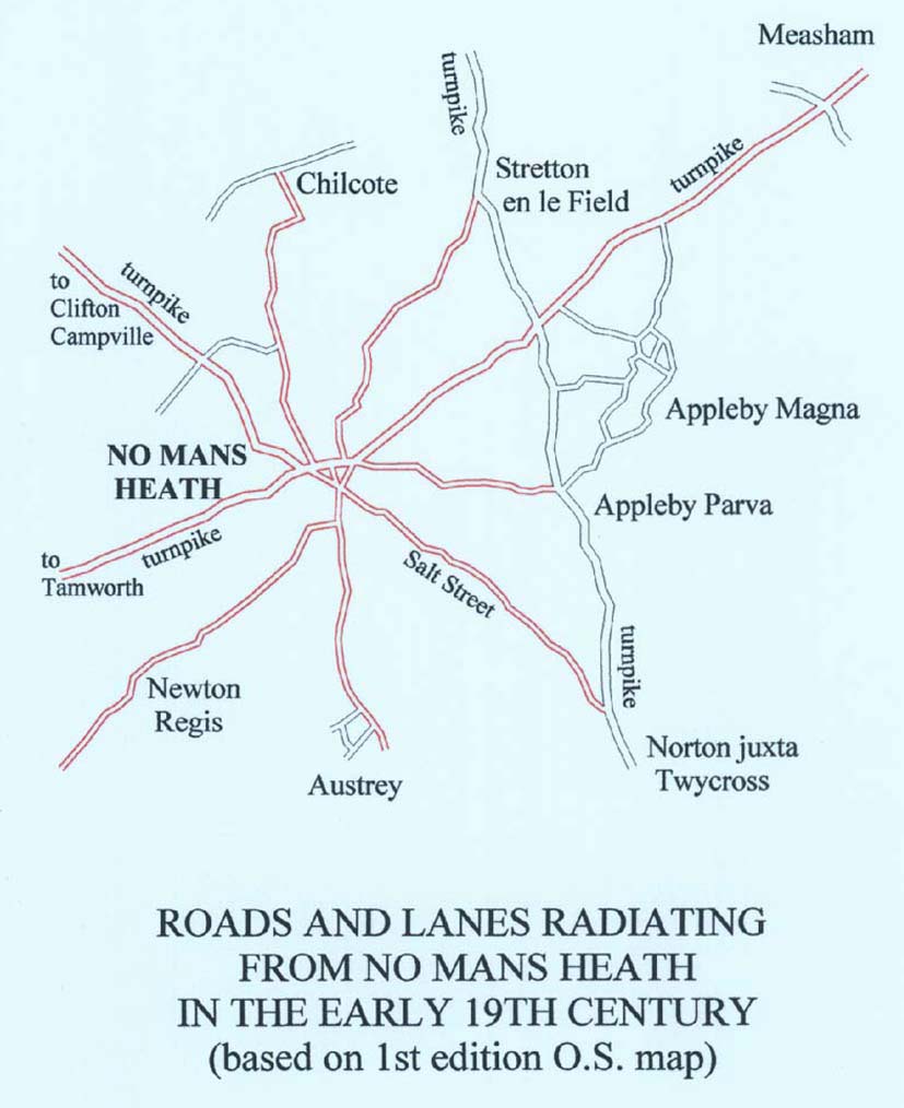
The point of speculating about the Roman road is that, when the Romans were farming in the Mease valley, a road system would have been a prerequisite for control of and access to the area. The strategic geographical position of No Man's Heath on the low western shoulder of the Appleby Hill ridge seems crucial and its location was used later to define land areas. It lies at a natural crossing point of the watershed between the valleys of the Anker and the Mease and is the focus of roads and tracks from nine directions, as well as for parish and county boundaries (see map 2). Many Roman travellers, and others before and since, must have passed through No Man's Heath.
|
Notes and References
ROLLR = Record Office for Leicester, Leicestershire & Rutland
Nichols = John Nichols, History & Antiquities of Leicestershire
TLAHS = Transactions of the Leicestershire Archaeological and Historical Society
1. Peter Foss, ‘Market Bosworth and its Region’ in Anglo-Saxon Landscapes in the East Midlands, ed. Jill Bourne, Leicestershire Museums Arts and Records Service, 1996.
2. R Millward, A History of Leicestershire and Rutland, Phillimore, 1985, 21 (Roman incursion) and 22-23 (Gartree Road). The Corieltauvi have also been known as the Coritani, as in the accepted Roman name for Leicester: Ratae Coritanorum
3. E Mammatt, Geographical Facts of the Ashby Coalfield, Lumley, 1836, 9 (Leicester Headland)
4. P Liddle & R F Hartley, ‘A Roman road through north-west Leicestershire’, TLAHS 68, 1994, 186
5. J Browning, 'Via Devana excavated at Bath Lane, Moira' (SK 312 154), TLAHS 73, 1999, 84-85
6. Nichols III 2, 1804, 1024 (Stretton-en-le-Field)
7. Jill Bourne, Place-names of Leicestershire and Rutland 1977, revised 1981; the place-name elements are all Old English.
8. An Archaeological Evaluation and excavation on Land at Rectory Lane, Appleby Magna, Leicestershire (SK 308 102), ULAS Report No. 2000/49. A short report by Sophie Clarke is in TLAHS, 74, 231, 2000. The archaeologicl evaluation report may be found at:
www.applebymagna.org.uk/appleby_history/images/ULAS_report_1999.pdf
For a summary see:
www.applebymagna.org.uk/appleby_history/misc_roman_remains.htm
9. Sir Ian Richmond, The Roman Villa in Britain (1969) challenged the idea that a Roman 'villa' was simply a grand house. He thought that a villa was basically a farm, a place designed for agricultural production. Although that interpretation has itself been challenged, with alternative economic activities suggested for other sites, the evidence at Appleby does point to a mainly agricultural function.
10. The ridge and furrow pattern of earlier arable farming preserved in the pasture of Job's Field shows several irregularities. There are lengthwise variations in the width of some ridges. There is also a large roughly rectangular area where broad ridges each divide into two narrower ones, perhaps forming a separate area of cultivation at a later period.
11. Appleby Magna Enclosure Award 1772, ROLLR, 15D55/44. 'To the said John Ragdale [rector of Appleby] one piece or parcel of land in the Job's Field ... containing 22 acres 1 rood 9 perches ...' in lieu of Glebe. See also Nichols IV ii, 430-431. His successor Thomas Jones erected a new Rectory (now the Old Rectory) in 1807, op.cit., 432. There is also reference to '... the Road leading from Great Appleby [Appleby Magna] to Burton herein called the Golden Way Road ...'
12. The Land of Burton Abbey at Appleby Magna, In Focus 8, this web-site
13. Appleby Church Restorations 3, In Focus 28, this web-site
14. David Farmer, The Oxford Dictionary of Saints, OUP (4th edit.)1997, St Helen (c.250-330)
15. The Glebe Terrier quoted by Nichols IV 2, 1811, 438, is listed in the Catalogue of Rolls and Charters in the British Library's Sloane Collection: Sloane Roll XXXI.9 'Terrier of Lands in Appleby, Norton and Snareston, co. Leic. Roll, 2 membranes', 15th century; acknowledgement to Mr Joe Maldonado of the British Library for providing the complete reference, especially the date.
16. Glebe Terrier, 21 April 1638, ROLLR, 15D55/43a; acknowledgement to Dr Alan Roberts for his transcription.
17. William Albert, The Turnpike Road System in England, Cambridge University Press 1972, 201-223, Appendix B ‘The Turnpike Acts 1663-1836’ includes 33 Geo. II (1760) Tamworth to Ashby.
18. Arthur Cossons, The Turnpike Roads of Leicestershire and Rutland, Kairos, 2003, 54, 56-7,
19. The Roman Coin Hoard at Money Hill is marked at SK 361 178 on OS Map SK 21/31 (1:25 000)
20. James Meek, Archaeology report on Ashby de la Zouch A50 by-pass, TLAHS 73, 1999, 84 (Roman features suggesting settlement near Old Parks House SK 360 188)
21. Revd Kenneth H Wayne, Excavation at Breedon on the Hill, TLAHS 47, 1971-72, 66. Aware of a possible Roman route from Breedon to Stretton en le Field Mr Wayne enlisted me in some field-walking near Stretton c.1973, but no Roman remains were found. This negative result lends credence to the idea that the 'street' is nearer the recently-found Roman site at Appleby, the 'high road' over the heath being the obvious candidate.
© Richard Dunmore, July 2000 and revised April 2010
Previous article < Appleby's History In Focus > Next article